Fodor's Expert Review The Perimetrale
An excellent road with some fabulous coastal views, the Perimetrale encircles the entire island, although its most interesting stretch is along the east and south coasts between Cala Cinque Dente and Scauri. Although you could drive the entire stretch in far less than an hour, exploring all the little coves and villages and taking a few walks could easily keep you busy for several days.
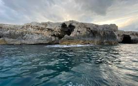
Cala Cinque Denti may literally mean "Bay of the Five Teeth", but opinions vary over which of the fearsome jagged rock formations inspired the name. The bay is most dramatically approached on foot from the signed car park at Punta Spadillo, from where a well-marked 30-minute path crosses a lunar landscape of black lava formations, scattered among which are doughnut-shaped gun emplacements dating back to World War II. A rocky branch of the path clambers down to the Laghetto Ondine, a natural pool fed by the sea, where you can swim under fabulous formations of lava. The main path continues along... READ MORE
An excellent road with some fabulous coastal views, the Perimetrale encircles the entire island, although its most interesting stretch is along the east and south coasts between Cala Cinque Dente and Scauri. Although you could drive the entire stretch in far less than an hour, exploring all the little coves and villages and taking a few walks could easily keep you busy for several days.
Cala Cinque Denti may literally mean "Bay of the Five Teeth", but opinions vary over which of the fearsome jagged rock formations inspired the name. The bay is most dramatically approached on foot from the signed car park at Punta Spadillo, from where a well-marked 30-minute path crosses a lunar landscape of black lava formations, scattered among which are doughnut-shaped gun emplacements dating back to World War II. A rocky branch of the path clambers down to the Laghetto Ondine, a natural pool fed by the sea, where you can swim under fabulous formations of lava. The main path continues along the clifftop, with more fantastic views, before climbing up to the top of Cala dei Cinque Denti.
The next stop along the Perimetrale is the picturesque village of Gadir, set around a sheltered inlet. The harborside has been smartly decked for sunbathing, and there are ladders into the inlet, from which you can swim out into the cove. Right by the water are three tomb-shaped pits enclosing hot water springs. Be warned that the temperature in one of them is dangerously hot so check before choosing which one to dunk yourself in. Following the path around the headland brings you to another (cool but protected) natural swimming pool, with two hot water springs behind it.
Driving on, you come to photogenic Cala Levante and Cala Tramontana, twin bays divided by a small peninsula. There is good swimming and sunbathing from each, and a narrow road continues south along the coast to the island’s most famous rock formation, the Arco dell’Elefante, which is said to resemble an elephant dipping its trunk into the sea. Little paths across the rocks lead to the best places to access the sea for a swim.
Returning to the Perimetrale, carry on south until the sign to Martingana, where a very steep but asphalted road curves down to a pretty settlement of lava stone and white-domed dammusi. The road then becomes a track (drivable even in an ordinary car) leading to a small car park where a path leads to a cove (with more good swimming) and where you can sunbathe atop a solidified river of lava. The next bay, Balata dei Turchi, can be reached by several clearly marked footpaths or along a rough and steep road, best attempted only by an adventurous driver. The bay is jaw-droppingly beautiful on a calm sunny day, backed by cliffs stained ochre, china blue, and rose by volcanic minerals, but can be quite inhospitable and forbidding in strong winds. Punta Nikà, reached by a steep track a little farther along the Perimetrale, has similar polychrome cliff formations and offshore hot springs accessible only in calm seas. The path to them is not signposted, but they're fairly easy to find. Instead of going downhill to the main bay, look for a narrow path after the first house on the left (with contemporary metal gates). Follow this downhill and along the perimeter of the house’s garden. At the bottom of the garden, follow the white arrows (a bit faded) which will guide you down to a place where you can get into the sea. Don’t attempt this track unless you are a fit and experienced hiker.
READ LESS